Ficheiro:SouthSudanStates.svg

Dimensões desta antevisão em PNG do ficheiro SVG: 422 × 315 píxeis Outras resoluções: 320 × 239 píxeis | 640 × 478 píxeis | 1 024 × 764 píxeis | 1 280 × 955 píxeis | 2 560 × 1 911 píxeis.
Ficheiro original (ficheiro SVG, de 422 × 315 píxeis, tamanho: 16 kB)
Descrição do ficheiro
| Descrição |
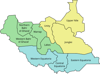
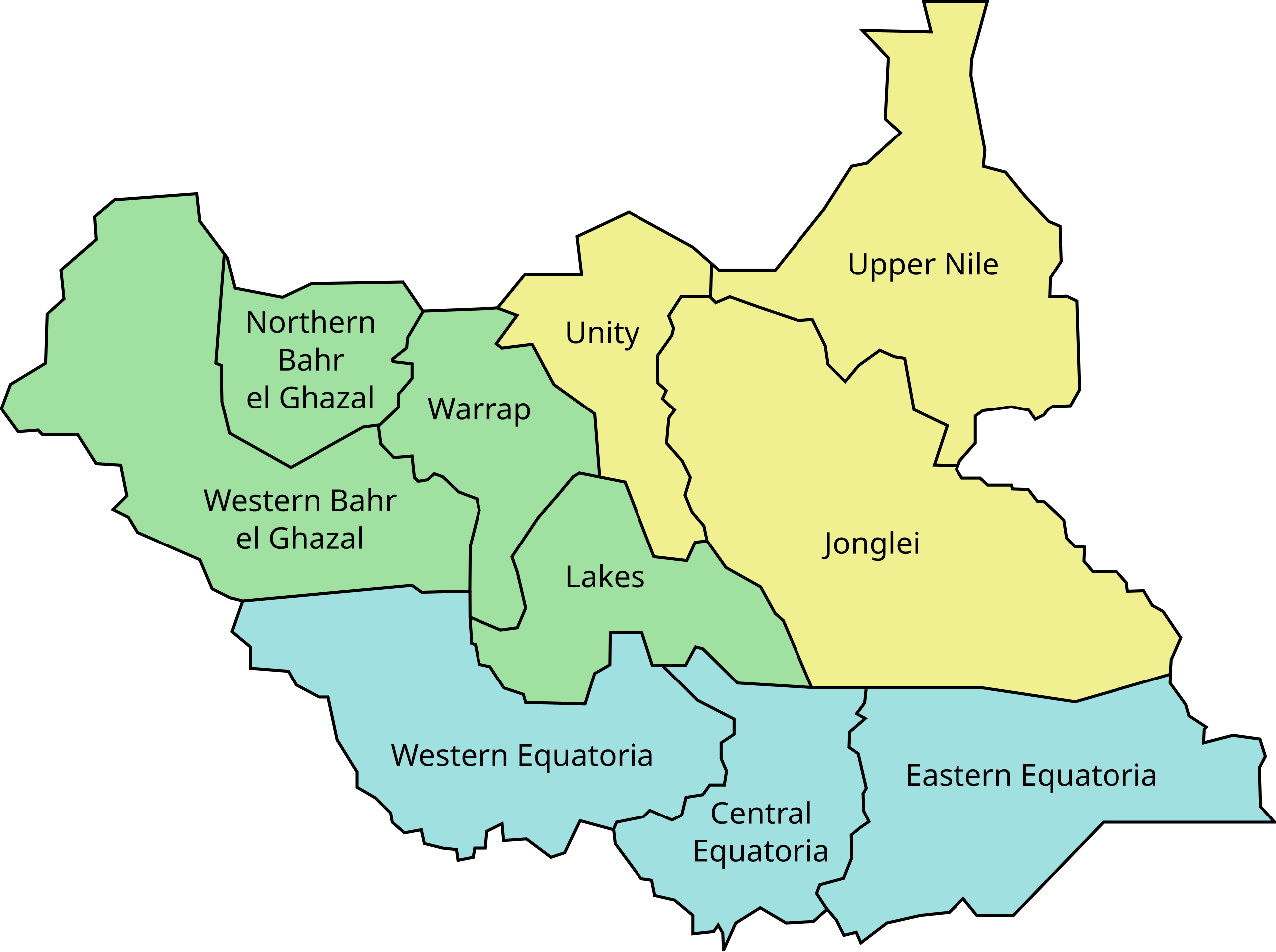
English: Map of South Sudan states as they existed from 2011–2015. These states and administrative areas are grouped into the three former historical provinces of the Sudan: Bahr el Ghazal (green), Equatoria (blue), Greater Upper Nile (yellow).
These were later divided into 28 states (2015–2017) then 32 states (2017–2020). In February 2020, as a result of a peace agreement that ended the South Sudanese Civil War, the country returned to the original 10 states plus two administrative areas, Greater Pibor and Ruweng, and the special administrative status area of Abyei (not pictured.) |
| Data | (UTC) |
| Origem | http://en.wikipedia.org/wiki/File:SudSudan.svg |
| Autor | Danielemezzalira |
| Outras versões |
|


| Este ficheiro SVG contém texto integrado que pode ser traduzido para a sua língua, usando qualquer editor SVG compatível, editor de texto ou a ferramenta SVG Translate. Para mais informações, consulte: Sobre a tradução de ficheiros SVG. |
Licenciamento
| Esta obra foi dedicada ao domínio público pelo autor, Danielemezzalira, com aplicação em todo o mundo. Nalguns países isto pode não ser legalmente possível; se assim for: Danielemezzalira concede a todos o direito de usar esta obra para qualquer fim, sem quaisquer condições, a menos que tais condições sejam impostas por lei.
|
Registo de carregamento original
Transferido de en.wikipedia para a wiki Commons por Stevenliuyi utilizando CommonsHelper.
A página de descrição original está aqui. Todos os nomes de utilizador a seguir referem-se a en.wikipedia.
- 2011-07-08 23:29 Brightgalrs 422×315× (15949 bytes) Fixed that misaligned text.
- 2011-07-08 23:24 Brightgalrs 422×315× (15955 bytes) {{Information |Description = |Source = |Date = ~~~~~ |Author = |Permission = |other_versions = }}
Histórico do ficheiro
Clique uma data e hora para ver o ficheiro tal como ele se encontrava nessa altura.
| Data e hora | Dimensões | Utilizador | Comentário | |
|---|---|---|---|---|
| atual | 04h25min de 9 de julho de 2011 | 422 × 315 (16 kB) | wikimediacommons>File Upload Bot (Magnus Manske) | {{BotMoveToCommons|en.wikipedia|year={{subst:CURRENTYEAR}}|month={{subst:CURRENTMONTHNAME}}|day={{subst:CURRENTDAY}}}} {{Information |Description={{en|Map of South Sudan}} |Source=Transferred from [http://en.wikipedia.org en.wikipedia]; transferred to Co |
Utilização local do ficheiro
A seguinte página usa este ficheiro: